 |
| Click below for ... | Do you hate maps?
Many people do. We often see them sitting in their cars at the side of the road with their map turned upside-down and a puzzled look on their faces. So . . . we have turned our maps upside-down for you, colored them with all sorts of useful information and then . . . . . . packaged them in a handy 6"x9" - 25 miles-per-page format so they easily fit in your lap while you are riding in your car. | 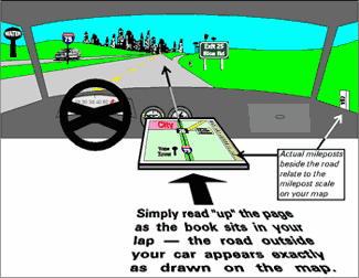 |
|
Now you can "drive by the book" - right up the page - it's very intuitive! Here's How . . .
"Along Interstate-75" contains two complete sets of 25 miles-per-page colored maps for your journey
Simply fold the book flat and place it in your lap with the direction you are traveling at the top of the page. The map now relates to the details of the road ahead. You read it from the bottom of the page towards the top. Everything drawn on the right side of the map appears on the right side of your car ... and vice versa ... it couldn't be simpler. |